Shell Mounds – or ‘shell middens’ – built by Indigenous people to recontour the landscape dot the park
For thousands of years the area now known as Upper Tampa Bay Conservation Park was the site of prosperous Native American communities. Recent archeological findings suggest that early residents used their discarded shells and other refuse to manipulate the estuarine waters they fished from-producing ideal fishing and oyster harvesting conditions.
In the late 1960’s a massive development project known as “Bay Port Colony” was proposed on approximately 3,000 acres of Upper Tampa Bay. Half of the area consisted of wetlands that were to be dredged and filled to provide waterfront housing. Due to public concern about the project’s irreversible and destructive effects on the environment, the plan was scrapped. Hillsborough County purchased the land, and in 1982 the park became a protected area for nature study and recreation.
Preserving Hillsborough County’s middens and archeological sites
The establishment of the park didn’t just preserve a unique range of natural habitats. It also protected fascinating cultural heritage sites and coastal terrains created by the Tocobaga and other Indigenous people. There are over 20 known archeological sites within the park, including several well-preserved shell middens.
Middens are durable human-made heaps consisting of animal remains, broken pottery, and other community refuse. Those in Upper Tampa Bay Conservation Park are mostly made up of oyster shells and take the form of low mounds or ridges. They were built-up over many centuries of Indigenous occupation and can still be found today.
Many shell mounds in coastal Florida were originally used for ceremonial purposes. Later in time, early European accounts suggest that some larger mounds also served as places of prestige where community leaders resided.
The shell middens in Upper Tampa Bay Conservation Park may have had an altogether different, or at least additional, purpose. It’s hypothesized that these mounds were created to protect estuarine habitats and to keep the mouth of the Double Branch Creek from shifting. Archeologists who have studied the area think that construction of these mounds and ridges may have begun roughly 2,000 years ago.
Dr. Kendal Jackson, a researcher at University of South Florida, specializes in landscape archaeology and has done extensive fieldwork in Upper Tampa Bay Conservation Park. He explained that the location of the middens indicate that the area was likely a hot spot for “fishing camps.” For thousands of years people lived around Double Branch Bay, either year-round or seasonally, taking advantage of the copious oysters, fish, and other animals available for hunting.
Over time, the shells and bones of consumed animals were piled in specific areas. The resulting mounds and ridges – some of which are still five feet high – helped control the flow of creek water and protect the coast from tidal surge and wave erosion.
The mounds may have also been a way for Indigenous groups to mark their territory or indicate prime spots for fishing or harvesting other aquatic animals. This would have been a practical use of discarded tools and leftover shells for an Indigenous community dependent upon Tampa Bay’s estuarine habitats.
Tocobaga and other early occupants
There is clear archaeological evidence that Indigenous peoples have occupied the Tampa Bay region for at least 10,000 years. Following the formation of the Tampa Bay estuary some 6,500 years ago, early occupants around Old Tampa Bay’s coast began intensively fishing and harvesting oysters. Carbon dated-artifacts from the park suggest that Indigenous people lived there as recently as 1300 AD. However, historical records and recent archaeological work at the Native town of Tocobaga (within Philippe Park) indicate that Native American communities continued to occupy the area up to the 1700s and later.
In addition to shell middens, Upper Tampa Bay Conservation Park has other archeological sites where European settlers established small fishing camps. Had the park been turned into a housing development, the middens and historic sites would surely have been destroyed. According to Jackson, the area is rich with archeological and anthropological significance.
“The park is one of very, very few examples in Tampa Bay where things have been left alone and an archeological record has been left in place. It’s a true gem,” Jackson said.

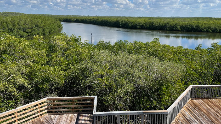
Mangroves can be seen from the nature center at Upper Tampa Bay Conservation Park..
Upper Tampa Bay Conservation Park
If archeology does not excite you, it’s likely one of the many other points of interest at Upper Tampa Bay Conservation Park may. The 596-acre park covers multiple habitats, including mangrove estuaries, tidal creeks, saltwater and freshwater marshes, oyster beds, coastal hammocks, and pine flatwoods. The diversity provides homes to a wide variety of animals, including many types of birds.
Visitors may hike the park’s three trails, rent kayaks and canoes for picturesque paddles, enjoy picnic shelters and a playground, and tour the Nature Center. The center features live fish, snakes, and turtles, along with interpretive exhibits.
It should be noted that any and all artifact collecting (including surface collecting) is strictly prohibited within Upper Tampa Bay Conservation Park, as well as all other Hillsborough County parks and preserves.
Upper Tampa Bay Conservation Park is at 8001 Double Brand Rd., Tampa, FL 33635.
Would you like to learn more about the Indigenous people of Hillsborough County? Read up on the Uzita, a tribe that lived in the Little Manatee River area (what is now Ruskin).
If you would like to get involved in local archaeology volunteering or have interest in public-education opportunities, you can find more information at the Florida Public Archeology Network and the Central Gulf Coast Archeological Society.
To read more stories about Hillsborough County conservation parks and preserves, subscribe to The Trailblazer newsletter.
Photo Information: The nature center at Upper Tampa Bay Conservation Park has maps and interpretive exhibits that describe the park environment, history, and geology.
