. DOI: 10.1016/j.jag.2023.103382")
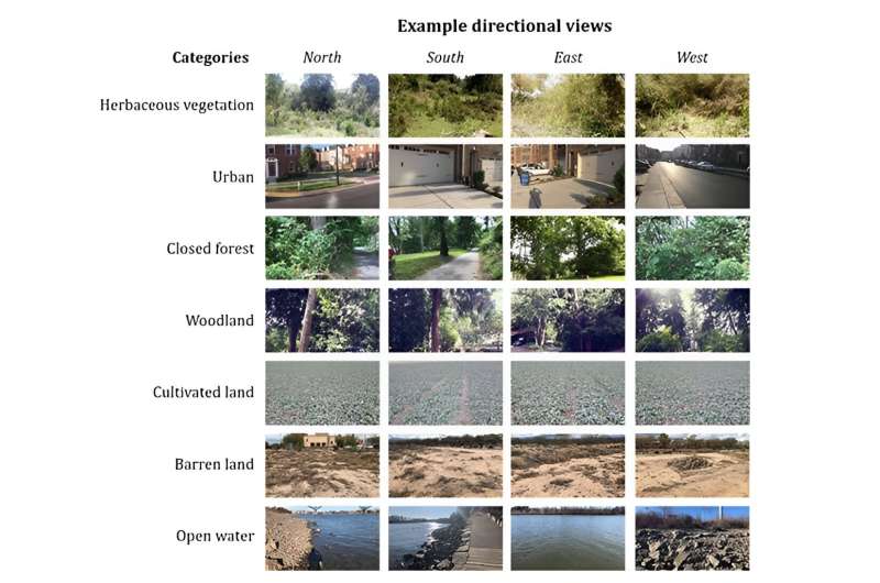
In 2019, the GLOBE Land Cover project began asking volunteers to help map planet Earth by taking photos of their surroundings facing multiple directions, including north, south, east and west. Now, a new paper published in the International Journal of Applied Earth Observation and Geoinformation by Xiao Huang and colleagues demonstrates how to combine these images using Artificial Intelligence (AI).
The paper compares this “multi-view” approach with the old single-view approach—and finds that the multi-view capabilities of the GLOBE Observer app, processed with AI, enable much more accurate mapping.
“We are thrilled about our recent discovery,” said Huang, the paper’s lead author. “We’ve observed that the current AI model is increasingly exhibiting human-like behavior, adept at integrating multiple perspectives, synthesizing them, and striving to derive meaning from these views.”
The most detailed satellite-based maps of our whole planet still can’t show details smaller than hundreds of meters [about 330 feet]. That means that a park in a city may be too small to show up on the global map. When you use the GLOBE Observer: Land Cover app, you help scientists fill in local gaps and contribute to consistent, detailed global maps that should us how our world is changing. Click here to join the project.
More information:
Xiao Huang et al, Land cover mapping via crowdsourced multi-directional views: The more directional views, the better, International Journal of Applied Earth Observation and Geoinformation (2023). DOI: 10.1016/j.jag.2023.103382
Provided by
NASA
Citation:
Artificial intelligence plus your cell phone means better maps of earth (2023, December 5)
retrieved 5 December 2023
from https://phys.org/news/2023-12-artificial-intelligence-cell-earth.html
This document is subject to copyright. Apart from any fair dealing for the purpose of private study or research, no
part may be reproduced without the written permission. The content is provided for information purposes only.