This video can not be played
To play this video you need to enable JavaScript in your browser.
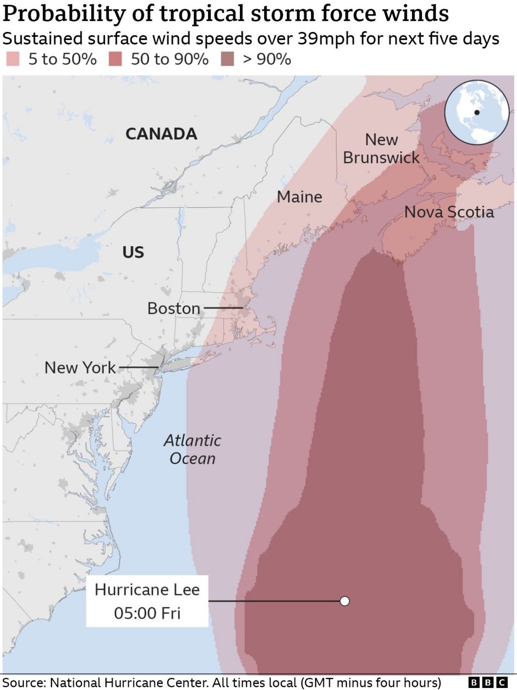
Hurricane Lee is heading north up the Atlantic and is expected to make landfall around Maine and Nova Scotia by this weekend.
Lee was a category one storm as of Friday morning, but the colder water temperatures of the Atlantic might weaken it.
Millions in coastal New England and parts of Canada are under storm warnings.
US authorities said it will be “large and dangerous”.
The storm has sustained wind speeds of 80mph (128km/h) and is currently 395 miles south of Nantucket, Massachusetts, according to the National Hurricane Center (NHC).
Lee, which is a couple of hundred miles north of Bermuda, has already whipped up strong winds and caused power outages throughout those islands.
Tropical storm conditions will begin in the southern New England area later on Friday.
The NHC said Lee will still be “a large and dangerous cyclone” that will bring strong winds, heavy rain and coastal flooding.
Because of the storm’s widening size, people will feel its impacts well beyond where the centre makes landfall.
“These conditions are likely to lead to downed trees and potential power outages,” the NHC said on Friday morning.
The centre said swells generated by Lee “are likely to cause life-threatening surf and rip current conditions” and could produce “localised urban and small stream flooding”.
Maine Governor Janet Mills declared a state of emergency and US President Joe Biden ordered resources from the Federal Emergency Management Agency to be deployed, in anticipation of the storm.
The state is expecting 20ft (6m) waves and wind gusts up to 70mph.
Lee is expected to dump its heaviest rain over Maine. Parts of New Hampshire, Massachusetts and Rhode Island will also have intense rainfall.
The last hurricane to hit Maine was Hurricane Gerda in 1969. In 1991, Hurricane Bob was downgraded to a tropical storm just before making landfall.
The Canadian Hurricane Centre has also issued hurricane and tropical storm watches for parts of Nova Scotia and New Brunswick.
Wildlife parks in Nova Scotia will be closed on Friday as Lee creeps towards the region.
“We are closing our parks for the storm and will reopen when it is safe,” said Tory Rushton, provincial minister of natural resources and renewables.
How much damage the storm will cause depends on its trajectory and any directional shifts before landfall. It is currently moving northward at a speed of 18mph.
If the storm shifts farther west, it could cause more damage in Maine, worsening coastal flooding.
Boston Mayor Michelle Wu anticipates the city will miss the worst of the storm, saying about 4in (10cm) of rain and wind gusts up to 30mph are expected.
