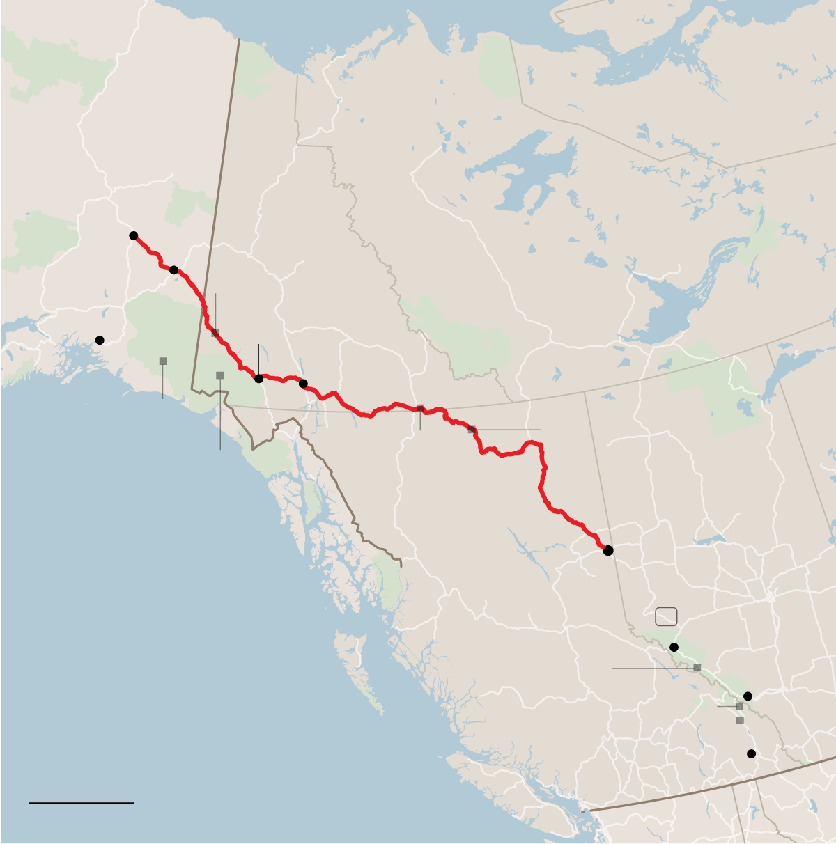
On an epic road trip, a family plots a course from Alaska to the Lower 48, passing through some of Canada’s most spectacular scenery. The tally: 2,200 miles, five national parks, numerous hot springs and one excellent reindeer hot dog.
Within months of the Pearl Harbor bombing on Dec. 7, 1941, the United States, in cooperation with the Canadian authorities, set out to build a highway from British Columbia to Alaska, then a territory and viewed as vulnerable to attack by Japan. The original 1,685-mile road took more than 10,000 soldiers less than nine months to complete.
An upgraded version opened in 1948 and has been continually resurfaced and rerouted; It now measures just shy of 1,400 miles from Dawson Creek, British Columbia, to Delta Junction in Alaska, according to “The Milepost,” a guidebook to the drive.
The highway formed the heart of a family road trip I took last September from Alaska to Idaho, passing through the Yukon, British Columbia and Alberta, in Canada, along the way.
#g-webALASKA-HIGHWAYmap-box ,
#g-webALASKA-HIGHWAYmap-box .g-artboard {
margin:0 auto;
}
#g-webALASKA-HIGHWAYmap-box .g-aiAltText {
position: absolute;
left: -10000px;
width: 1px;
height: 1px;
overflow: hidden;
white-space: nowrap;
}
#g-webALASKA-HIGHWAYmap-box p {
margin:0;
}
#g-webALASKA-HIGHWAYmap-box .g-aiAbs {
position:absolute;
}
#g-webALASKA-HIGHWAYmap-box .g-aiImg {
position:absolute;
top:0;
display:block;
width:100% !important;
}
#g-webALASKA-HIGHWAYmap-box .g-aiSymbol {
position: absolute;
box-sizing: border-box;
}
#g-webALASKA-HIGHWAYmap-box .g-aiPointText p { white-space: nowrap; }
#g-webALASKA-HIGHWAYmap-600 {
position:relative;
overflow:hidden;
}
#g-webALASKA-HIGHWAYmap-600 p {
font-family:nyt-franklin,arial,helvetica,sans-serif;
font-weight:500;
line-height:13px;
height:auto;
opacity:1;
mix-blend-mode:normal;
letter-spacing:0em;
font-size:12px;
text-align:left;
color:rgb(0,0,0);
top:1px;
position:static;
text-transform:none;
padding-bottom:0;
padding-top:0;
font-style:normal;
}
#g-webALASKA-HIGHWAYmap-600 .g-pstyle0 {
height:13px;
letter-spacing:0.05em;
text-transform:uppercase;
position:relative;
}
#g-webALASKA-HIGHWAYmap-600 .g-pstyle1 {
font-style:italic;
height:13px;
opacity:0.5;
letter-spacing:0.05em;
text-transform:uppercase;
position:relative;
}
#g-webALASKA-HIGHWAYmap-600 .g-pstyle2 {
font-style:italic;
height:13px;
letter-spacing:0.05em;
text-transform:uppercase;
position:relative;
}
#g-webALASKA-HIGHWAYmap-600 .g-pstyle3 {
height:13px;
position:relative;
}
#g-webALASKA-HIGHWAYmap-600 .g-pstyle4 {
height:13px;
opacity:0.5;
mix-blend-mode:multiply;
position:relative;
}
#g-webALASKA-HIGHWAYmap-600 .g-pstyle5 {
font-weight:700;
line-height:18px;
height:18px;
font-size:16px;
top:1.3px;
position:relative;
}
#g-webALASKA-HIGHWAYmap-600 .g-pstyle6 {
line-height:16px;
height:16px;
letter-spacing:0.025em;
font-size:9px;
text-align:center;
top:0.7px;
position:relative;
}
#g-webALASKA-HIGHWAYmap-600 .g-pstyle7 {
font-family:nyt-cheltenham,georgia,serif;
font-style:italic;
line-height:14px;
height:14px;
font-size:13px;
text-align:center;
color:rgb(102,102,102);
}
#g-webALASKA-HIGHWAYmap-600 .g-pstyle8 {
height:13px;
opacity:0.5;
mix-blend-mode:multiply;
text-align:right;
position:relative;
}
#g-webALASKA-HIGHWAYmap-600 .g-pstyle9 {
height:13px;
text-align:right;
position:relative;
}
#g-webALASKA-HIGHWAYmap-600 .g-pstyle10 {
height:13px;
font-size:9px;
text-transform:uppercase;
top:0.7px;
position:relative;
}
#g-webALASKA-HIGHWAYmap-335 {
position:relative;
overflow:hidden;
}
#g-webALASKA-HIGHWAYmap-335 p {
font-family:nyt-franklin,arial,helvetica,sans-serif;
font-weight:500;
line-height:11px;
height:auto;
opacity:1;
letter-spacing:0em;
font-size:11px;
text-align:left;
color:rgb(0,0,0);
top:0.9px;
position:static;
text-transform:none;
padding-bottom:0;
padding-top:0;
mix-blend-mode:normal;
font-style:normal;
}
#g-webALASKA-HIGHWAYmap-335 .g-pstyle0 {
height:11px;
letter-spacing:0.05em;
text-transform:uppercase;
position:relative;
}
#g-webALASKA-HIGHWAYmap-335 .g-pstyle1 {
height:11px;
position:relative;
}
#g-webALASKA-HIGHWAYmap-335 .g-pstyle2 {
font-style:italic;
line-height:12px;
height:12px;
letter-spacing:0.05em;
text-transform:uppercase;
position:relative;
}
#g-webALASKA-HIGHWAYmap-335 .g-pstyle3 {
font-style:italic;
line-height:12px;
height:12px;
opacity:0.5;
letter-spacing:0.05em;
text-transform:uppercase;
position:relative;
}
#g-webALASKA-HIGHWAYmap-335 .g-pstyle4 {
font-weight:700;
line-height:15px;
height:15px;
font-size:14px;
top:1.1px;
position:relative;
}
#g-webALASKA-HIGHWAYmap-335 .g-pstyle5 {
line-height:13px;
height:13px;
letter-spacing:0.05em;
font-size:12px;
text-transform:uppercase;
top:1px;
position:relative;
}
#g-webALASKA-HIGHWAYmap-335 .g-pstyle6 {
font-family:nyt-cheltenham,georgia,serif;
font-style:italic;
line-height:13px;
height:13px;
font-size:12px;
text-align:center;
color:rgb(102,102,102);
}
#g-webALASKA-HIGHWAYmap-335 .g-pstyle7 {
height:11px;
text-align:right;
position:relative;
}
#g-webALASKA-HIGHWAYmap-335 .g-pstyle8 {
height:11px;
font-size:9px;
text-transform:uppercase;
top:0.7px;
position:relative;
}

alaska
northwest
territories
Yukon
Delta
Junction
Lake Creek
Campground
Tok
Haines
Junction
Valdez
Alaska
Highway
Whitehorse
Wrangell-St. Elias
National Park &
Preserve
Liard River Hot Springs
Provincial Park
Signpost
Forest
Kluane National
Park & Reserve
Alberta
British
Columbia
Dawson Creek
canada
40
Columbia
Icefield
Skywalk
Jasper
Pacific
Ocean
Banff
Kootenay National Park
Radium Hot Springs
Kimberley
200 miles
united states

alaska
Delta
Junction
Yukon
northwest
territories
Haines
Junction
Tok
Valdez
Alaska
Highway
Whitehorse
Wrangell-St. Elias
National Park &
Preserve
Alberta
British
Columbia
Kluane
National
Park &
Reserve
Dawson
Creek
canada
Jasper
Pacific
Ocean
Banff
Kimberley
united
states
200 miles
Relying on Google Maps won’t get you far on this drive, where cellphone service is sparse. In preparation, my son found a 1972 road map of western Canada and eastern Alaska that has remained fairly accurate.
The route, which takes motorists through some of the most stunning landscapes in North America, lends itself to a budget trip. We spent about $300 on fuel for the whole trip in a medium-size S.U.V. We often camped and ate picnic meals, starting in coastal Valdez, Alaska, where we overnighted on a 32-foot powerboat listed on Airbnb ($68 a night) with a great blue heron and a harbor seal as neighbors.
We are having trouble retrieving the article content.
Please enable JavaScript in your browser settings.
Thank you for your patience while we verify access. If you are in Reader mode please exit and log into your Times account, or subscribe for all of The Times.
Thank you for your patience while we verify access.
Already a subscriber? Log in.
Want all of The Times? Subscribe.